By Rick Kelson on May 13, 2020
2019 and 2020 Utah Aerial Lidar Acquisition
This article will take 2 minutes to read
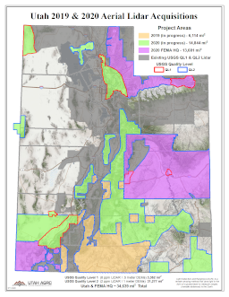
AGRC has awarded Aero-Graphics, Inc. and The Sanborn Map Company, Inc. to acquire 20,958 square miles of aerial lidar elevation data. The lidar will be a combination of USGS Quality Level 1 (QL1), 8 points per square meter and Quality Level 2 (QL2), 2 points per square meter depending on the area. The 2019 QL2 project covering portions of Kane County, Utah was acquired last fall, is going through USGS Quality Assurance, and is scheduled to be completed by June 30, 2020. The 2020 acquisitions have begun and will continue throughout the year. These project areas will be completed in 2021 and project deliverables are scheduled to be completed by June 30, 2021.
The Federal Emergency Management Agency, the U.S. Forest Service, and the U.S. Geological Survey (USGS) National Map 3D Elevation Program (3DEP) are also acquiring 13,681 square miles of aerial lidar in Utah this year. The lidar will mostly be QL2, with a few small areas as QL1. The acquisitions will begin in the fall of 2020 and project deliverables are scheduled to be completed by June 30, 2022.
You are welcome to download the boundaries for all the project areas as a shapefile.
The Project Areas Include
- Grand Staircase-Escalante National Monument
- Bears Ears National Monument
- Capitlol Reef National Park
- Arches National Park
- Flaming Gorge National Recreation Area
- Glen Canyon National Recreation Area
- Sections of the Green and Colorado Rivers
- Portions of the Greater Sevier Watershed
- Portions of the Manti-La Sal, Fishlake, Ashley, Wasatch-Cache, Uintah, and Dixie National Forests
- Areas within:
- All 29 Utah Counties
- 58 of the 253 Utah Municipalities
- 30 of the 249 Utah Cities & Towns
The Project Deliverables
- Raw Point Cloud
- Classified Point Cloud (2 or 8 points per square meter with 10cm vertical RMSE)
- Ground (bare earth)
- Water
- Bridge decks
- Snow (if present and identifiable)
- Low and High Noise
- Processed, but unclassified
- Bare-Earth Terrain Model (DTM) (0.5 or 1 meter cell size with 10cm vertical RMSE with Hydro-Flattening)
- First Return Surface Model (DSM) (0.5 or 1 meter cell size with 10cm vertical RMSE) (not available for FEMA HQ areas)
- Intensity Images (0.5 or 1 meter resolution GeoTIFFs) (not available for FEMA HQ areas)
- Metadata
The Project Partners
- U.S. Geological Survey National Map: 3D Elevation Program (3DEP)
- Federal Emergency Management Agency (FEMA)
- Utah Division of Emergency Management
- National Resource Conservation Service
- U.S. Forest Service
- Utah Geological Survey
- Cryq Energy, Inc.
Comments, questions, compliments, or concerns can be directed to Rick Kelson from AGRC at RKelson@utah.gov.
