By Bert Granberg on Jul 09, 2013
AGRC Base Map Services Now Accessible via ArcGIS Online
This article will take 1 minute to read
 AGRC is beginning limited use of ESRI's combination data portal and SaaS technology, ArcGIS Online (AGOL). Over the next few months, we will be experimenting with AGOL as an alternate/complementary channel for accessing some data and services within Utah's State Geographic Information Database (SGID). AGRC's AGOL site is https://utah.maps.arcgis.com.
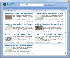
The 7 AGRC Base Map Services for Utah -- Hybrid, Terrain, Aerial, Lite, Streets, Topo, and Hillshade-- are now accessible from within AGOL. These services are also accessible, without navigating the AGOL middleware portal, via REST interface.
Additionally, this means that ArcGIS Desktop users can access the base maps via the Add Data button's Add Data From ArcGIS Online command. In this case, we recommend searching for 'AGRC Base Map' to quickly narrow down the hunt.