By Bert Granberg on Jul 07, 2016
Data Schema Released for Expanded GIS Parcel Sharing
This article will take 1 minute to read
In May, the Land Information Records work group, a committee of county, regional, and state agencies, released its recommendations for sharing an enhanced set of tax parcel GIS data, summarized in a this blog post.
In a letter to Utah’s County Assessors, Evan Curtis, the State Planning Coordinator with the Governor’s Office of Management and Budget, provided a nice overview of the work done on this initiative:
Working together, Curtis wrote, we’ve been able to arrive at a solution that should provide regional and statewide planners, economic development professionals, emergency managers, and others with the data tools they need to make informed decisions without placing an undue burden on the counties and avoiding issues that would come with the addition of personally-identifiable information
Several next steps from the recommendations document are now in motion.
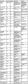
- A submission guidelines document, including a recommended data schema for submissions, was created by AGRC and reviewed by the Assessors and the work group representatives
- Download LIR parcel data schema
- An initial data submission ‘ask’ was made to Counties in late June
- As part of the first round of submission, AGRC is volunteering technical support to assist Counties in loading parcel boundaries and tax assessment data into the recommended enhanced schema
For this first submission year, the enhanced tax parcel layer will likely take some time to assemble across the state, but many counties have indicated they plan to submit later this month. The tax parcel layer will be updated on gis.utah.gov and on the SGID SDE server as submissions are received.
