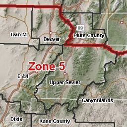
Conservation Districts and Zones

Conservation Districts and Zones
- Category: Boundaries
- Data Type: GIS Data Layer
- Steward(s): AGRC & USDA-NRCS
- Abstract: This dataset contains GIS mapping data pertaining to the soil conservation district and zone boundaries created by the US Department of Agriculture, National Resource Conservation Service.
Conservation Districts

This dataset shows the Conservation District (formerly Soil Conservation District) boundaries in the state of Utah. This dataset was created to update district and zone boundaries to conform to the boundary descriptions as approved by the Utah Soil Conservation Commission.
The native spatial reference for this dataset is UTM Zone 12N, NAD83 (0.01 meter coordinate precision). The dataset is maintained by the AGRC in cooperation with US Department of Agriculture, National Resource Conservation Service.
Comments, questions, compliments, or concerns can be directed to the staff from AGRC at agrc@utah.gov or 801-538-3665.
Downloads and Web Services
Updates
- 2000
Conservation Zones

This dataset shows the Conservation District (formerly Soil Conservation District) zone boundaries in the state of Utah. This dataset was created to update district and zone boundaries to conform to the boundary descriptions as approved by the Utah Soil Conservation Commission.
The native spatial reference for this dataset is UTM Zone 12N, NAD83 (0.01 meter coordinate precision). There are no constraints or warranties with regard to the use of this dataset. Users are encouraged to attribute content to: State of Utah. The dataset is maintained by the AGRC in cooperation with US Department of Agriculture, National Resource Conservation Service.
Comments, questions, compliments, or concerns can be directed to the staff from AGRC at agrc@utah.gov or 801-538-3665.
Downloads and Web Services
Updates
- 2000