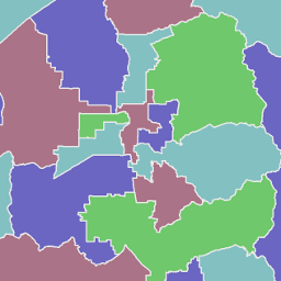
2002 - 2011 House, Senate and Congressional Districts
Note: New political boundaries were used for the first time during the Fall 2012 election. Elected officials representing the new 2012 districts took office in January 2013.

2002 - 2011 House, Senate and Congressional Districts
- Category: Political
- Data Type: GIS Data Layer
- Steward(s): AGRC and the Lieutenant Governor's Office
- Abstract: These political districts were used for election purposes from January 1, 2002 through December 31, 2011 and for purposes of elected representation and other purposes through Dec 31, 2012. This dataset includes the political districts used for the Utah State Legislature (state senate districts and state house districts); and U.S congressional districts.
State House Districts

The Utah House of Representatives is comprised of 75 men and women elected to two-year terms. Political.UtahHouseDistricts2002 show the house districts that these elected officials represented in 2002. The DIST field contains the House district number.
The COLOR4 field is for use in coloring districts using only 4 colors with no adjacent districts displayed with the same color.
There are no constraints or warranties with regard to the use of this dataset.
Related Resources
Downloads and Web Services
Updates
- This dataset was last updated in 2002.
State Senate Districts

The Utah State Senate is comprised of 29 men and women elected to four-year terms. Political.UtahSenateDistricts2002 shows the senate districts that these elected officials represented in 2002. The DIST field contains the Senate district number.
The COLOR4 field is for use in coloring districts using only 4 colors with no adjacent districts displayed with the same color.
There are no constraints or warranties with regard to the use of this dataset.
Statewide Political District Boundaries are drawn by the Utah Legislature and adopted into state law.
Related Resources
Downloads and Web Services
Updates
- This dataset was last updated in 2002.
United States Congressional Districts

U.S. congressional house districts determine the districts that elect a representative to send to the U.S. Congress. Utah currently had three congressional house districts until 2012 when it was increased to four. Political.USCongressDistricts2002 shows the three congressional districts. The DIST field contains the Congressional district number.
There are no constraints or warranties with regard to the use of this dataset.
Statewide Political District Boundaries are drawn by the Utah Legislature and adopted into state law.
Related Resources
Downloads and Web Services
Updates
- This dataset was last updated in 2002.