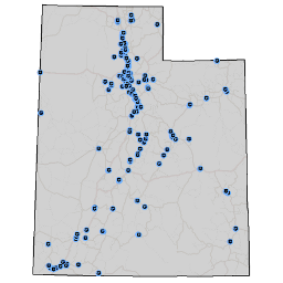
Public Safety
- Category: Society
- Data Type: GIS Data Layer
- Steward(s): AGRC
- Abstract: This data package has three datasets with facilities relating to public safety in Utah. Public safety facilities include correctional facilities, fire stations, and law enforcement facilities. These datasets come from different sources and therefore there might be some overlap.
Correctional Facilities

Society.CorrectionalFacilities contains locations for jails and prisons in Utah. A jail or prison defined by the Department of Justice consists of any facility or location where individuals are regularly and lawfully detained against their will. This includes Federal and State prisons, local jails, and juvenile detention facilities, as well as law enforcement temporary holding facilities. Locations which function primarily as law enforcement offices are included in this dataset if they have holding cells.
There are no constraints or warranties with regard to the use of this dataset.
Comments, questions, compliments, or concerns can be directed to the staff from AGRC at agrc@utah.gov or 801-538-3665.
Downloads and Web Services
Updates
- June 2013
- August 2011
Fire Stations

Society.FireStations includes any location where fire fighters are stationed or based out of, or where fire fighting equipment is stored. This definition includes fire stations that are both private and public entities, and fire stations that primarily fight forest or grassland fires. Fire fighting training academies are also included.
Comments, questions, compliments, or concerns can be directed to the staff from AGRC at agrc@utah.gov or 801-538-3665.
Downloads and Web Services
Updates
- June 2013
- August 2011
Law Enforcement

Society.LawEnforcement contains locations for law enforcement facilities in Utah. Law enforcement facilities are defined as any location where sworn officers of a law enforcement agency are regularly based or stationed. Law enforcement facilities are at least partially publicly funded. This law enforcement dataset includes federal, state, local and special jurisdiction facilities. Examples of law enforcement facilities included are municipal police, county sheriffs, state police, school police, park police, railroad police, and federal police.
Comments, questions, compliments, or concerns can be directed to the staff from AGRC at agrc@utah.gov or 801-538-3665.
Downloads and Web Services
Updates
- June 2013
- August 2011
PSAP Locations

Society.PSAPLocations represents the primary Public Safety Answering Point (PSAP) locations in Utah. The Salt Lake County Sheriff Office PSAP is secondary. The dataset was created in December 2004 by geocoding the PSAP addresses provided by the E911 Executive Committee.
Comments, questions, compliments, or concerns can be directed to the staff from AGRC at agrc@utah.gov or 801-538-3665.
Downloads and Web Services
Updates
- January 28, 2020 - Updated name of Central Utah 911
- December 10, 2018
- November 25, 2013
- December 2004
PSAP Boundaries

Society.PSAPBoundaries represents Primary Safety Answering Point (PSAP) boundaries in Utah. Countywide PSAP jurisdiction boundaries are based on the SGID10.BOUNDARIES.Counties data layer, as of July 26, 2012. PSAP jurisdictions representing individual cities are based on the SGID10.BOUNDARIES.Municipalities data layer, as of July 26, 2012. The data also includes jurisdictional boundary representations of the Navajo Nation Tribal Lands, Hill Air Force Base, and Colorado City.
Comments, questions, compliments, or concerns can be directed to the staff from AGRC at agrc@utah.gov or 801-538-3665.
Downloads and Web Services
Updates
- January 28, 2020 - Added Centerville to Bountiful PD jurisdiction. Adjusted municipality-centric boundaries to account for recent annexations. Updated name of Central Utah 911.
- January 4, 2019
- December 10, 2018
- November 25, 2013
- October 16, 2013
State Agency Dispatch

Society.StateAgencyDispatch represents State Dispatch Boundaries.
Comments, questions, compliments, or concerns can be directed to the staff from AGRC at agrc@utah.gov or 801-538-3665.
Downloads and Web Services
Updates
- October 2013