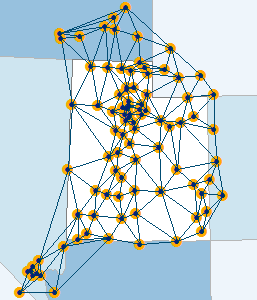
The Utah GPS Network

What Is a Reference Network?
A GPS Network is a high-precision global navigation satellite system (GNSS) providing real-time corrections and data for post processing. A GNSS network consists of permanently located GPS receivers, installed across the state, that generate real-time, high-accuracy GPS positioning. Basically, all of the permanently installed GPS receivers send their data to a system that analyzes the input and adjusts and corrects the data to provide the most accurate locations.
About this Network
The coordinate reference frame for this network is NAD83(2011)(EPOCH:2010.0000.). The latitude, longitude, and ellipsoidal height of each reference station were calculated by processing 24 hour files using the National Geodetic Survey (NGS) Online Positioning User Service (OPUS) Projects application.
Eighteen NGS Continually Operating Reference Stations (CORS) were selected along the perimeter and interior of the network and were constrained to the published coordinates to conduct the final adjustment of the network coordinates.
With an activated subscription, set your GPS unit's VRS connection address to 168.179.231.9 and port 2101. Enter your new device-specific username and password.
Connections from Source Table
For Trimble units we have these different connections.
- VRSCMRX works with the newest Trimble units, newest firmware.
- VRSCMRP works with Trimble units that are newer but may not have the latest updates to the firmware.
- VRSCMR works with older Trimble units.
For non-Trimble units use these connections.
- VRSRTCM32 works with newest non-Trimble units.
- VRSRTCM31 works with non-Trimble units.
- VRSRTCM23 works with older non-Trimble units.
All of these give you the network solution. They just deliver it in different ways and in some cases nano-seconds slower.
MS_CMR, MS_CMRP, and MS_RTCM31 are for connecting to a single base when you are on the edge of a network or are not getting a strong network solution. In these cases, the system will automatically find the closest station and connect you.
Getting Started
Create an Account
Visit The Utah Reference Network GPS Payment and select New Registration, then follow the instructions. The cost is $600 and you now get access to the Nevada GPS covering Washoe County in Nevada. You'll need a credit card, and the following information...
- Organization (avoid punctuation)
- Login
- Password (8 characters)
- Contact Name, email, phone number
- Physical location/address
- Mailing address
Renew an Account
Visit The Utah Reference Network GPS Payment and select Renew Subscription. The cost is $600 and you now get access to the Nevada GPS covering Washoe County in Nevada. You'll need a credit card, and the following information...
- Organization (avoid punctuation)
- Login
- Password (8 characters)
When done you will receive a confirmation email and receipt. If the account has expired, it will take about 24 hours for the subscription payment to cycle through and the activation to be complete for field work, otherwise you will not notice any interruption.
Support Contacts
If you have questions or require help contact the Support Desk from DTS at agrc@utah.gov or 1-800-678-3440, or Mike Heagin from AGRC at mheagin@utah.gov or 385-401-9667, or Sean Fernandez from AGRC at sfernandez@utah.gov.