By JP on Apr 16, 2013
Progress Update, Utah Address Points GIS Layer
This article will take 3 minutes to read
 AGRC is currently working with County governments to build a statewide address point dataset. To date, AGRC has collected over 846,000 address points from Counties, many of which received, through AGRC, address point development grant funding from the National Telecommunications and Information Administration (NTIA) within the US Department of Commerce. Later this Spring, AGRC will publish the address point dataset to its statewide address locator web service and will otherwise make this data resource available. Locally, these County grantees have all designated a single point of contact for addressing and processes to web-enable their address inventory for use internally and externally.
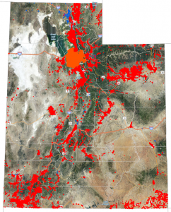
The map at right shows the great progress made on the statewide address point layer. On the map, address points have been drawn in red and orange over blue-colored populated locations (2010 census). While this looks good, there is still work to be done beyond the data intake and quality assessment processes. Several counties submitted partial submissions and/or are working to complete and improve their inventories. For example, Salt Lake County has established an Address Division and is meticulously reviewing addresses and associated documentation to produce an authoritative address list as well as an ongoing stewardship processes. In other areas, AGRC is actively working to assist the Counties with their inventory.
Address 'geocoding' is an automated process that, using algorithms and map reference data, provides geographic coordinates for an address. Compared to geocoding addresses using street centerline map reference data that carries address range information, address points can substantially improve the precision of the geocoding results. And precision is critical when addresses are close to the boundaries of cities, precincts, and other services districts. Address points have already been used in Utah to increase the accuracy of assigning voter residences to precincts, and are also fast becoming an interest of those involved in public safety response. Address points are also helpful in determining where populated or developed areas are, especially in rural areas. This will be a key ingredient to sharpening the resolution of data collection and planning efforts related to high-speed internet service deployment in the state.
Part of AGRC's process for building a statewide address list has been facilitating discussions and giving presentations on address point standards and the benefit of address points. So far, AGRC has participated in group discussions and/or presented to the relevant professional groups including the: Utah Association of Counties, Utah 911 Committee, SLCC Geomatics PAC, UVU Geomatics Advisory Board, Utah Council of Land Surveyors, Central Utah GIS Users Group Meeting, and the Utah Geographic Information Council Conference.
AGRC has worked hands-on with Utah Counties to ensure high quality data is being entered into the statewide Address point dataset. AGRC and Counties either meet in person or remotely to review data quality checks and maintenance processes.
Data quality checks include, but are not limited to:
- Review on where the X,Y falls in relation to the structure (on the house, parcel entry, etc).
- Address data component completeness
- Comparison to other address lists such as tax rolls, registered voter lists, etc.
- Completeness for the developed and populated areas in a county
</ul>
Lastly, a suggestion for ongoing study of the statewide address point database was included in the Master Study Resolution (#65) passed into law during the 2013 General Session of the Utah Legislature. As a result, statewide address points, the associated upkeep process, and the important applications for this data are likely to be highlighted during 2013 Interim Legislative season.
Additional address point resources:
- NSGIC Addressing Coordination Issues (PDF Document - 3/22/10)
- Address Points for the Nation (PDF Document - 5/3/11)
- Proposed Best Practices for Managing Address Inventories