By Mike Heagin on Aug 28, 2015
Public Lands Survey System (PLSS) Version 2.0, 2015 updates
This article will take 1 minute to read

AGRC recently made available the latest version of the Geographic Coordinate Database (GCDB) version 2.0, 2015 updates to the Townships, Sections, and Quarter Section divisions of the Public Land Survey System (PLSS) contained in Utah’s State Geographic Information Database (SGID).
The basic units of the PLSS comprise the foundation for public and private property boundaries in Utah. The digital GIS representations of the PLSS in the SGID, while in no way a substitute for physical surveys and monumentation, serve as an important supporting reference for surveying and map-based administrative representations of property extents.
In the next month we will be getting all the contributed PLSS Corner Points integrated with this new BLM version of this feature class and updating it here. Stay tuned we will have more changes on the way.
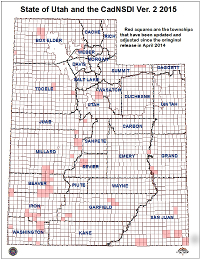
The Township areas impacted by change in this updated version are shown on the map and include adjustments to the locations of corner points.
Download Options
GCDB v2.0, as provided to AGRC by the Utah state office of the BLM, can be downloaded in the CADNSDI data format and conforms to the newest Federal Geographic Data Committee (FGDC) guidelines for geospatial data. The CADNSDI data format is available for download.
AGRC derived GIS layers that have been updated in the SGID are:
- SGID10.Cadastre.PLSSTownships_GCDB
- SGID10.Cadastre.PLSSSections_GCDB
- SGID10.Cadastre.PLSSQuarterSections_GCDB
- SGID10.Cadastre.PLSSQuarterQuarterSections_GCDB
- SGID10.Cadastre.PLSSPoint_GCDB
- SGID10.Cadastre.MeanderedWater_GCDB (available on request)
- SGID10.Cadastre.MetadataGlance_GCDB (available on request)
- SGID10.Cadastre.SpecialSurveys_GCDB (available on request)
To download and view more information about the data listed above please visit the plss data page.
