By JP on May 29, 2014
Significant Changes to the Utah Land Ownership GIS Layer
This article will take 1 minute to read
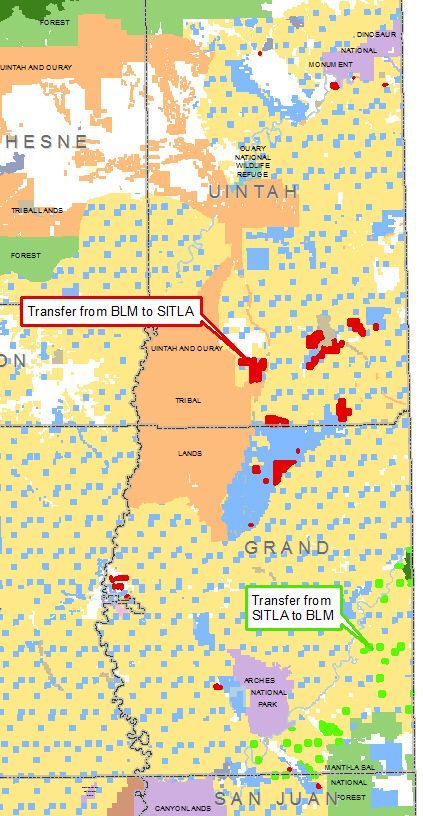
 Utah's School and Institutional Trust Lands Administration (SITLA) and the Bureau of Land Management (BLM) finalized a 60,000 acre land swap on May 8, 2014.
As a result, significant land ownership changes have been published to the SGID10.CADASTRE.LandOwnership GIS layer today, May 29, 2014 (Download or View this data). These updates reflect the conveyance of land between SITLA, BLM, and Private ownership.
The Utah Recreational Land Exchange Act of 2009 was signed by President Obama and became law on August 19, 2009. Under the Exchange Act, the BLM and SITLA consolidated land ownership through an equal value exchange of lands in Uintah, Grand and San Juan counties. The exchange protects environmentally-sensitive lands along the Colorado River corridor and helps position SITLA with lands more suitable for development.
The BLM acquired 58 parcels with high conservation and recreation value, totaling 25,034 acres, primarily in Grand County. These parcels will expand the BLM backcountry with world class recreation sites like Corona Arch and Morning Glory Arch.
SITLA acquired 34 parcels with high mineral development potential, totaling 35,516 acres, primarily in Uintah County. The Administration expects development of these high potential parcels to increase public school funding across Utah.
Completion of the Exchange Act adds to the 540,000 acres of sensitive lands SITLA has helped to conserve and protect while earning more than $1.4 billion for the beneficiaries of trust lands, primarily Utah public schools.
Comments, questions, compliments, or concerns can be directed to the GIS staff from SITLA at TLA-GIS@utah.gov or 801-538-5100.